
Clouds are often a presence on the sky. We all see them from the ground, yet the best view we can get on them is always from above. Observing the clouds from above we can understand well enough that they are clearly the reason why we have different weather condition on the ground, and why there is a certain temperature during the day and another one during the night. As you’ve probably noticed clouds have different sizes and they are mostly white. Personally I find this very interesting. Let’s take a closer look.
WHY CLOUDS ARE MOSTLY WHITE?
During the night we barely notice if there are clouds on the sky, during the night the sky is black and so are the clouds. Yet during the day we see them as a kind of white gaseous formation in the sky. That means, it must have to do with the light coming from the sun. This can be explained as follows:
While light from the sun passes straight through many of the water droplets in a cloud. Sooner or later it will hit a droplet of water in the cloud and be reflected, just as the sun is reflected off the surface of a lake. This bounces the light off in another direction, so it hits another droplet and is reflected again. This continues, and the ray of light is bounced around like a pinball until it leaves the cloud. When it finally reaches your eyes, you see a pinprick of light originating from the last droplet of water that the light bounced off. The same happens to all the other rays of light that hit the cloud, so that what your eye sees is billions of pinpricks of light originating from all over the cloud.
Some of these rays of light will have taken longer routes and lost their brightness, and so that part of the cloud will appear darker. Your brain tries to make sense of all these pinpricks of light. It is used to interpreting shades of light and dark in reference to a 3-dimensional object, which has material characteristics that correlate with what you are seeing. This is why, when we travel by plane and we watch the clouds through the window inside the airplane cabin, clouds appear to be objects, sometimes fluffy as if made of wool, and sometimes denser, as if they might be a floating mountain.
Of course, another bit of your brain denies all this, and points out to your subconscious that these are not objects at all, but tricks of the light. Still, even knowing this, it’s hard to see clouds as just an agglomeration of water droplets. Much of the beauty of the sky is due to clouds and their water content. It affects the light we perceive in myriad ways and is one of the main reasons why different places in the world are so sublimely different in terms of light. But as the tiny droplets that make up a cloud become more dense, it becomes harder and harder for light to bounce its way through from top to bottom, and the cloud appears dark gray. We all know what this means, especially in Britain—it’s going to rain.
HOW CLOUDS FORM?
This happens by condensation and depends largely by the type of air present in the environment. For clouds to form, there are two main types of air: Stable Air and Unstable Air.

STABLE AIR = > Air is warmed when it is in contact with the ground. This causes it to become less dense than the cooler air above and so it starts to rise. So on a sunny day the water molecules make their way from your washings or water puddles up into the atmosphere. The air, though full of water, is transparent, so at first there won’t be any sign of a cloud. As air moves upwards, its temperature falls at a set rate, the lapse rate, making it denser and heavier as its height increases. Eventually the rising air reaches a point at which it is more dense than the surrounding air and it starts to sink again. This air is said to be stable
UNSTABLE AIR => As air rises and cools, the amount of water vapour it can hold decreases until it becomes saturated and water droplets form. The temperature at which this happens is referred to as the dew point. The height of the dew point is not fixed and varies according to air temperature and the amount of moisture present. In these conditions, a rising pocket of air is always warmer than that surrounding it. At the dew point, the air becomes saturated with water vapour and clouds start to form. It is the individual droplets that make up a cloud and initially are of course too small to be seen and they are also transparent. A typical cloud droplet or ice crystal is about 0,01mm across. If the saturated air is cooling at a slower rate than the surrounding air, it will also be warmer and so it will continue to rise. This air that rises without being forced is referred to as unstable.
============================
Therefore Clouds form when water vapour in rising air condenses into droplets or freezes directly into ice crystals. As the vapor goes higher, the air expands and cools, and the thermodynamic balance is tipped toward H2O molecules preferring to condense and be part of a liquid again. Cold clouds formed at high altitude contain only ice crystals, lower-altitude warm clouds contain only water droplets, and mixed clouds contain both.
Snowflakes form if ice crystals and water droplets cool to below freezing. Water evaporates from the droplets and is deposited on the ice crystals, which collide and form snowflakes. Fog and dew form when condensation occurs at ground level, but if temperatures fall below freezing, dew is replaced by frost and rime.
Condensation is the change that takes place when a gas, such as water vapour, changes into a liquid, such as water. Therefore it could sound hard to reconcile a cloud as being fundamentally liquid, but it is. As we know, a water-vapour molecule consists of elements, 2 hydrogen and 1 oxygen, that move freely among the molecules of the other atmosphere gases. When two water molecules collide, they bounce off each other. But a single molecule can’t just turn back into liquid in midair; to form a tiny droplet of water requires some coordination—several H2O molecules all have to come together to become a single droplet. However as the temperature falls, the molecules have less energy and move more slowly. When they reach the dew point temperature, at which water condenses, water-vapour molecules join together when they meet.
A hydrogen bond forms between one of the hydrogen atoms of one molecule and the oxygen atom of another, forming them into short strings. The water vapour has then condensed into a liquid. As they join, the molecules fall into a state that requires less energy to sustain it, and so they give up some of their energy as heat. This is called latent heat. Its release warms the surrounding air and may be absorbed by liquid molecules allowing them to vaporize. Thus groups of water molecules are constantly breaking and re-forming. Clouds form at the dew point and may attain great depth under these conditions.
The tiny spherical water drops that are floating in the cloud start to get bigger, and gravity begins to exert a greater force on them. When the droplets are just the size of tiny dust particles, buoyancy and air convection currents exert a far greater force on them than gravity does, so they just float around like dust. But as they get bigger, gravity starts to dominate, pulling them down toward Earth and turning them into rain. If we’re lucky, that is; otherwise they may form a storm cloud, the very storm clouds that kill hundreds of people every year.
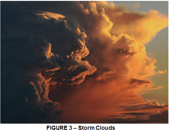
Storm Clouds like the one shown in Figure 3 form in unstable air. Water vapour condenses, releasing latent heat so the air continues to rise. Violent vertical currents in the cloud may produce a thunderstorm.
The Lake Effect Snow = In Winter, large lakes, such as Lake Superior, USA are slow to freeze. Air crossing them gather moisture that condenses into clouds as it passes over cold land forming a specific type of clouds known as Lake Effect Clouds. The Lake Effect phenomenon is well-known and studied in meteorological circles. At times, there is a large temperature contrast between the surface air and lake water, and cloud formations can deliver heavy lake effect snows on the downwind shores of the lakes.For example Northern or westerly winds blow over the lakes’ surface, picking up heat and water vapor that produce warm columns of air known as “thermals.” Those columns then cool down and condense into cumulus clouds, aligning in the direction of the prevailing wind over the lakes’ surface. When there is a large enough temperature contrast, the cloud structures can dump heavy lake effect snow on the downwind shores of the lakes.

In general clouds occur worldwide, but are not uniform. Different clouds form under different climatic conditions.

Leave a comment